

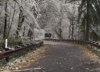
“A strong cold front is still moving through the area, bringing a periods of rainfall. Recent snow accumulations in the Willapa Hills and northern Oregon Coast range will add to runoff, exacerbating the potential for flooding.” National Weather Service of Portland Tweeted. Several weather alerts are in place as Oregon and Washington are expecting heavy snowfall for the Cascades, intense wind gusts region wide, and significant rainfall for coastal cities. People should plan for possible downed trees and power outages.
Wind speeds are expected to kick up to 35 to 45mph from the south. In higher terrain, wind gusts could possibly reach 75mph. The strongest winds are expected Sunday afternoon. These winds will be on top of forecasted heavy rainfall.
This weather system is expected to bring a two to a four-hour period of heavy rainfall. That rain, plus snow melt-off from the lower elevations of the Willapa Hills and the north Oregon coast range could increase the risk for flooding. Portland, faster-responding rivers will sharply rise sharply Monday but are unlikely to reach the flood stage with the first round of rain. However, they may rise again Tuesday and Wednesday. Most rivers will continue to rise through the week.
Minor flooding, up to one foot above ground level in the central Oregon coast and up to 1.5 feet above ground level in the north Oregon, south Washington coast, during high tides is expected in the low lying areas near bays, sloughs, and the lower reaches of the coastal rivers.
Eight to 16 inches of total snow accumulations are possible. Below 500 feet in elevation, four to eight inches is expected. In Washington, this warning covers the central Columbia River Gorge. In Oregon, this warning covers upper Hood River Valley and central Columbia River Gorge.


